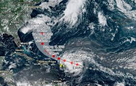
Hurricane Erin Caribbean: What You Need to Know
Hurricane Erin Caribbean has officially become the Atlantic season’s first hurricane of 2025, strengthening rapidly as it heads toward the northeastern Caribbean. With sustained winds around 75 mph (Category 1) and expected to intensify into a major hurricane (Category 3 or possibly Category 4) by this weekend, its impact could be significant.
Authorities have issued tropical storm watches for several islands including Anguilla, Barbuda, St. Martin, St. Barts, Saba, and St. Eustatius. Meanwhile, islands like Puerto Rico, Antigua & Barbuda, and both the U.S. and British Virgin Islands are bracing for heavy rainfall—up to 6 inches in isolated spots—plus dangerous surf and rip currents.
Erin is projected to pass north of the Leeward Islands but still could unleash flooding, landslides, and coastal erosion, especially as warmer-than-usual Atlantic waters fuel its rapid intensification.
While the current forecast keeps Erin offshore of the U.S. mainland, its powerful swells—potentially up to 15 feet—could affect the East Coast, especially North Carolina.
Why This Matters
- Safety First: Local authorities and travelers must stay alert to evolving watches and warnings.
- Disaster Preparedness: Forecast models suggest potential severe inland impacts despite the storm staying offshore.
- Climate Trends: Erin’s unrest is driven by record-warm ocean conditions—a red flag for an active hurricane season.
Internal Resource
Thinking of future travels? Start planning your next adventure with us—book your Colombia tours here and explore this vibrant country safely, even as the Caribbean weathers Erin.
External Authority Link
For a detailed breakdown of the 2025 hurricane season including Hurricane Erin’s stats and impact history, visit the Wikipedia entry on the 2025 Atlantic hurricane season.


